Home | Welcome | What's New | Site Map | Glossary | Weather Doctor Amazon Store | Book Store | Accolades | Email Us
Weather Events
Significant Severe Cyclones
Striking Bangladesh
The region now known as Bangladesh (previously Bengal and East Pakistan) has been struck by severe tropical cyclones many times over the centuries. Many of the world's most deadly weather events have been attributed to these storms. During the period 1980-2000, nearly 60 percent of the world's total death toll due to tropical storms occurred in Bangladesh, including the single most deadly event: a severe cyclone striking on November 1970 which took 300,000 to 500,000 lives. Of the ten deadliest tropical storms in world history, eight have occurred in the Bay of Bengal, and all have over 100,000 fatalities attributed to them. Fourteen of the deadliest twenty storms also arose in the Bay.
A combination of geographical and social conditions contribute to the high death toll. The roughly triangular shape of the Bay of Bengal has its apex along its northern shoreline which includes the full coast of Bangladesh. This shape funnels the storm surge pushed by the severe tropical storms (known as cyclones or cyclonic storms in the region) onto the Bangladesh coast. The shape is accentuated by the shallow waters which allow the build-up of high storm surges. The devastation caused by these surges can be especially destructive, and deadly, when they occur at astronomical high tide. Bangladesh is a very low country, particularly in its southern coastal regions where the elevation of the land does not exceed 10-15 metres (33-50 ft) above sea level in height. Much of it sits on the delta of the Ganges-Brahmaputra-Meghn Rivers and is very susceptible to flooding.
Composite of Cyclone Tracks Crossing
the Bay of Bengal (1970 to 2005)
Click Here for larger image.
Source: Wikimedia Commons
Added to the geographical factors is the fact that Bangladesh is a poor, mostly agricultural nation whose residents generally live in homes made from local materials unable to withstand the onslaught of hurricane-force winds and storm surge. The fertile soil of the delta makes it a prime location for subsistence farms but a deadly location when severe cyclones hit.
Deadly Cyclones Striking Bangladesh
The accounts of deadly cyclones striking the region that is now Bangladesh stretch back over four centuries. The earliest on record struck the Bakerganj (presently Barisal) and Patuakhali regions, reportedly killing 200,000 in 1582. (According to Banglapedia, 2 million "living creatures" died, but it is not known if this represents only people, includes livestock, or is a typographical error). A cyclone crossed the Sunderban coast in 1699 and reportedly killed 50,000 people. The third cyclone with a high number of reported casualties (>10,000) to strike the region prior to 1800 did so in 1767, crossing the Backerganj (Barisal) coast with surge height estimated at 13 m (43 ft). This storm reportedly took 30,000 lives. Cyclones in 1760, 1765 and 1797 were reported to have caused great destruction of homes, but no estimates of the number of dead are available, though the toll was likely high.
A storm that struck the coast in October 1737 caused widespread damage in Calcutta and British and French reports from the region (Bilham, 1994 ) gave the loss of life at 300,000 (ten times the "official" estimates). The deaths initially were attributed to an earthquake, but Bilham found no evidence for a quake and suggests the death toll, which included fatalities from further east along the shore in present-day Bangladesh, was due to a very severe cyclone. That a storm surge can hit the coast with such force as to resemble an earthquake is not without precedent (the surge that hit Long Island New York in 1938 was recorded on seismographs as far away as Alaska).
Fourteen major cyclones struck the region during the 1800s. Most of the information on these storms have been extracted by Wikipedia from the publication by F. Henderson. Disastrous storms in the Bay of Bengal, A Listing of Cyclonic Storms by Month Through 1979 (prepared for the Office of U.S. Foreign Disaster Assistance Agency for International Development, Washington DC). Among the deadliest (where estimates are known) occurred in 1822, 50,000 dead; 1831, 22,000; 1876, 200,000; and 1897, 175,000.
The last of these is known as The Great Backerganj Cyclone of 1876. The cyclone formed over the southeastern Bay of Bengal on 27 October and moved northward toward the Backerganj coast over the next few days while intensifying to a full severe cyclonic storm. It struck the coast near the Meghna River estuary at present-day Barisal on 31 October. The storm winds have been estimated at 220 km/h (119 knots) with a storm surge height of 3.0 to 13.6 m (10–45 ft). Reports indicate that half the dead were killed by the storm surge, and the remainder died of disease and famine resulting from the storm's devastation.
Cyclones Tracking Over Bangladesh During the Twentieth Century
Click Here for larger image.
Source: Banglapedia
In the last century, the deadliest storm in the region was the Great Bhola Cyclone of November 1970 for which the estimated death toll ranged from 350,000 to 550,000. Cyclone 02BB struck the Chittagong region a few months later on 29 April 1991 and claimed 138,000 lives. Other high death tolls (>10,000) during the 1900s occurred in 1960, 10,000 deaths; 1961, 11,468 deaths; 1963, 11,520 deaths; 1965, 19,279 deaths; 1985, 11,069 deaths.
Since 2000, the deadliest storm to hit Bangladesh was Very Severe Cyclonic Storm Sidr. The official death toll has been given at 3,447 deaths. However, Save the Children estimated shortly after the storm that the number of deaths could be between 5,000 and 10,000, while the Red Crescent Society reported the number could reach 10,000.
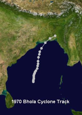
The 1970 Bhola Cyclone
This cyclone formed over the central Bay of Bengal on the morning of 8 November 1970, likely from the remnants of a tropical storm which arose in the South China Sea then moved west over the Malay Peninsula on 5 November into the Bay of Bengal. The system headed northward as it intensified. The India Meteorological Department upgraded it to a cyclonic storm on the 9th and a severe cyclonic storm on the 11th. As it approached the East Pakistan (Bangladesh) coast, the storm had a central pressure as low as 950 mb, and its sustained winds blew at 185 km/h (115 mph), making it a Category 3 hurricane on the Saffir-Simpson Hurricane Scale.
Track for Bhola Cyclone, November 1970
Source: Wikimedia Commons
Image of the Bhola cyclone taken on 11 November 1970.
Courtesy US NOAA
The cyclone made landfall near Chittagong during the evening of 12 November about the same time as the day's high tide. The Chittagong meteorological station, located 95 km (59 mi) to the east of landfall, recorded sustained winds of 144 km/h (89 mph) before losing its anemometer at about 2200 UTC. A ship in the port reported a gust of 222 km/h (138 mph) shortly thereafter. The storm pushed a 10-metre (33 ft) high surge across the Ganges Delta and a 4 m (13 ft) storm tide into Chittagong, 1.2 m (3.9 ft) of which was the due to storm surge.
The surge and winds killed all those living on 13 islands near Chittagong and nearly 18 percent of those resident in the directly affected region. The southern half of Bhola Island was completely devastated as were the rice crops on that island, Hatia Island and the nearby mainland coastline. Survivors claimed that 85 percent of the area homes were destroyed or severely damaged. Approximately 9000 marine fishing boats were lost and 60 percent of the 77,000 onshore fishermen died. Fish supply the major source of protein to the local inhabitants, and the loss of nearly two thirds of the fishing industry was a severe blow to this impoverished region. Agricultural production sustained similar damage due to loss of crops and 280,000 head of cattle.
Once over land, the storm began to weaken but was still considered a cyclonic storm on 13 November when it sat about 100 km (65 miles) south-southeast of Agartala. Then it rapidly weakened into a remnant low over southern Assam that evening.
The storm's damage estimate came to $86.4 million US dollars (1970), the equivalent of $450 million 2006 US dollars. The death toll ranged from 300,000 to 550,000 with more than half the dead being children under ten who formed a third of the pre-cyclone population. The true figure will never be known as many bodies were washed to sea or buried in the delta and, it is suggested, that the deaths of migrant workers were not included in the fatality estimates.
Post-storm studies concluded that warnings about the impending storm were not fully issued, and thus a large part of the population were caught unaware. Of those that heard the warnings, only about one percent reportedly sought refuge in fortified structures.
East Pakistani political leaders were very critical of the Pakistan government's response to the storm and relief efforts following it, charging the government with "gross neglect, callous indifference and utter indifference." In the aftermath, the split between East and West Pakistan grew and soon deteriorated into the Bangladesh Liberation War in March 1971. This conflict would widen into the Indo-Pakistani War of 1971 in December and concluded with the creation of an independent Bangladesh.
An offshoot of the storm and consequent political situation was the formation of the Cyclone Preparedness Programme in 1972 under the World Meteorological Organization and run today by the government of Bangladesh and the Bangladesh Red Crescent Society. The programme's objectives are to raise public awareness of the risks of cyclones and to provide training to emergency personnel in the coastal regions of Bangladesh. Since the cyclone, over 200 cyclone shelters have been built throughout the coastal regions of the country.
The 1991 Bangladesh Cyclone
On the list of the world's deadliest tropical storms, the 1991 cyclone ranks ninth, taking nearly 140,000 lives. The storm struck on the night of 29 April 1991 in the Chittagong district of southeastern Bangladesh.
Track of 1991 Bangladesh Cyclone
April 1991
Source: Wikimedia Commons
1991 Bangladesh Cyclone near peak
intensity on April 29 at 0623 UTC.
Courtesy US NOAA / Satellite and Information Service
The storm's birth was first noticed a week earlier when an area of cloud developed into a tropical depression. Over the next two days, its size increased to cover nearly the entire Bay of Bengal, and its wind speed increased so that it became Tropical Storm 02B. As the tropical storm moved northwestward, it strengthened into a full cyclonic storm on the 27th. Intensifying to a very severe cyclonic storm on the 28th, it took a turn to the northeast, a heading that would take it to southeastern Bangladesh.
Over the next two days, Cyclone 02B rapidly grew to the equivalent of a Category 5 hurricane with sustained winds of over 255 km/h (160 mph), its estimated minimum pressure falling to 898 mb. When it struck the coast south of Chittagong late on the 29th, its winds had diminished slightly to around 250 km/h (155 mph), a strong Category 4 storm. Cyclone 02B pushed a wall of water 6 metre (20 ft) high inland over a wide swath of shoreline.
The deadly combination of high storm winds and high storm surge hammered the coastline. A concrete levee erected near the mouth of the Karnaphuli River in Patenga to protect against storm surge washed away under the storm's onslaught. The winds lifted a 100-ton crane located in the Port of Chittagong and dashed it into the Karnaphuli River Bridge, breaking the bridge in two. The storm destroyed approximately 1 million homes and many boats and small ships in Chittagong harbor, leaving about 10 million people homeless. The storm also struck a hard blow on the Bangladesh military, severely damaging the Bangladesh Navy and Bangladesh Air Force bases there. The storm caused an estimated $US 1.5 billion ($US 2.28 billion in 2007 dollars) in damage.
Flooded villages and fields around a river in Bangladesh
the day after the 1991 Bangladesh cyclone
Courtesy US Air Force Defense Visual Information Center
Photo by Staff Sergeant Val Gempis
The official death estimate set the figure at 138,000 with the highest mortality among children and the elderly (greatest among under-10-year-olds (26%) and women older than 40 years (31%)). Most of the deaths in the Chittagong district were due to drowning. Despite the construction of many storm shelters since the Bhola cyclone, many residents received the storm warnings only a few hours before it hit. Some who did not seek the shelters reported that they did not know where to go, and others refused to believe the storm would be as bad as forecast. On the bright side of the deadly leger, over 2 million people reportedly did make it to the shelters, even though only 2 of 5 shelters were usable due to flooding. Over twenty percent of those who did not reach a concrete or brick structure died, whereas all persons taking refuge in such structures survived.
As it moved over land, the storm rapidly weakened and dissipated the following day over southeast Asia.
Cyclone Sidr
Cyclone Sidr, aka Cyclone 06B, rates low on the list of deadly Bangladesh/Bay of Bengal tropical storms, but its death toll was still pegged at about 3500 individuals. Initial estimates by Save the Children and the Red Crescent Society suggested the number of deaths might be between 5,000 and 10,000. Even with the conservative official figure, the storm count is nearly double that attributed to Hurricane Katrina, considered a major killer storm in the US.
Track of Cyclone Sidr
November 2007
Source: Wikimedia Commons
Tropical Cyclone Sidr (06B) in the Bay of Bengal,
as seen by the MODIS instrument aboard
NASA's Terra satellite on November 14 at 0445 UTC.
Courtesy of MODIS Rapid Response Project at NASA/GSFC
Cyclone Sidr is also noteworthy for its peak winds of 260 km/h (160 mph) on 15 November 2007, making it the second strongest tropical storm to hit Bangladesh since reliable record keeping began in 1877, exceeded only by the 1991 storm. Such winds rate the storm as Category 5 on the Saffir-Simpson Scale, or a Super Cyclonic Storm using the local storm designation.
Sidr began as an area of cloud organized southeast of the Andaman Islands on 9 November. It officially became Tropical Cyclone 06B on 11 November, and early the next day, the India Meteorological Department upgraded the storm to Cyclonic Storm Sidr. The storm headed slowly northwestward, gaining strength as it intensified and reached very severe cyclonic storm status on the 13th. By the morning of 15 November, the Joint Typhoon Warning Center best track estimated that the storm winds had reached 260 km/h (160 mph) with minimum central pressure at 944 mb.
Cyclone Sidr made landfall along the northern Bay of Bengal coast near the border between the Indian State of Tamil Nadu and Bangladesh, a region known as the Sunderbans, late on 15 November with sustained winds at 215 km/h (135 mph), a Category 4 storm, and measured storm surge of 3 metres (9.8 ft) at Chennai in Tamil Nadu and over 5 meters (16 ft) in the Patuakhali, Barguna and Jhalokati Districts of Bangladesh. Calculations suggest the highest surge may have reached 6.1 to 7.6 metres (20-25 ft) along the Sunderbans coast to the right of the storm's eye.
Map showing affected districts of Bangladesh due to Cyclone Sidr, November 2007.
Courtesy Humanitarian Information Unit, US Department of State
The surge flattened tin shacks and the wind blew away houses and schools. Local agricultural took a severe blow as most of the rice crop, due to be harvested in December, was devastated. Estimated loss of crops reached 95 percent in eleven coastal districts with high additional loses to the cattle and shrimp farming industry. The shrimp hatcheries in Satkhira, Khulna and Cox's Bazar were badly affected. Further inland, much of the capital city of Dhaka reported significant damage due to winds and flooding with electricity and water service cut for most residents. Over 3,000 fishermen were reported missing on over 500 fishing boats. Total damages came close to $US 1.7 billion (2007 dollars).
Coastal Damage due to Cyclone Sidr.
Courtesy U.S. Navy, photo taken by
Mass Communication Specialist Seaman Christopher Lange
At least 3,447 deaths have been reported but these do not include the missing fishermen. The death toll may have been much higher had not the storm struck directly on the Sunderbans, a nearly uninhabited portion of the coast. The City of Barguna suffered the most fatalities, 423 according to local officials. Patuakhali was also hard-hit with 385 deaths reported. Most of these deaths were blamed on the strong winds. An estimated two million people in Bangladesh evacuated to emergency shelters, an evacuation prompted by predictions of storm surge by a numerical model developed by Dr. Hassan Mashriqui of Louisiana State University. The Indian Meteorological Department also issued a cyclone alert for Orissa and West Bengal.
In addition to the destruction delivered to the human population and infrastructure along the storm's path, Sidr severely damaged about a quarter of the Sunderbans, a UNESCO World Heritage Site. The Sunderbans is the world's largest mangrove forest and its unique ecosystem is home for the famed and endangered Bengal tiger. Located in the estuary of the Ganges and Brahmaputra river systems, the Sunderbans provides extensive habitats for wildlife including many endangered species.
Sidr hit the eastern parts of the forest including Kochikhali, Kotka, Hiron Point, and Dublarchar, plowing a path of severe devastation. Experts on the unique region feared many animal species including tigers, crocodiles, king cobras, monkeys, wild boars and deer were swept away by the storm surge or perished under the weight of uprooted trees. UNESCO reported at least 40 percent of the forest had been seriously damaged. Some researchers estimated the Sunderban's mangrove forest will take at least 40 years to recover.
Return to Part I: The Deadly Cyclones of Bangladesh
For an album of images: Cyclones of Bangladesh: Images
Map of northern Bay of Bengal coastline
showing Bangladesh and surrounding nations.
Learn More From These Relevant Books
Chosen by The Weather Doctor
* Burt, Christopher C.: Extreme Weather: A Guide and Record Book, 2004 (pb), W. W. Norton & Company, ISBN 039333015X.
* Heidorn, Keith C.:And Now...The Weather, 2005, Fifth House, ISBN 1894856651
* Williams, Jack: The Weather Book, 1997, Vintage Books, ISBN 0-679-77665-6.
Written by
Keith C. Heidorn, PhD, THE WEATHER DOCTOR,
November 1, 2008
Significant Severe Cyclones Striking Bangladesh ©2008, Keith C. Heidorn, PhD. All Rights Reserved.
Correspondence may be sent via email to: see@islandnet.com.
For More Weather Doctor articles, go to our Site Map.
I have recently added many of my lifetime collection of photographs and art works to an on-line shop where you can purchase notecards, posters, and greeting cards, etc. of my best images.
To Purchase Notecard,
Greeting Cards and Posters
featuring my images, visit
The Weather Doctor's
Nature Gallery
In association with Zazzle.com
Now Available! Order Today!
NEW! Now Available in the US!
And Now...The Weather
by Keith C. Heidorn
To Order in Canada:
And Now...The Weather
by Keith C. Heidorn
The BC Weather Book:
From the Sunshine Coast to Storm Mountain
by Keith C. Heidorn
source:www.islandnet.co
No comments:
Post a Comment